|
The online world map of coal and peat fires is a web accessible site showing the location of known and reported coal and peat fires worldwide. The world map is designed with the popular Google Maps as a background and uses enhanced functionality of the standard Google Maps to help the user navigate to an area of interest. In this easy to navigate web site, coal fire locations are marked with a special fire icon. At the broadest level a user can view the major coal and peat fires sites at the continental scale. With successive clicks on the coal fire icons, the user can zoom into finer national, regional and local scales. At the local scale the user can see the location of the fire in the context of its surrounding landscape. Information, such as the location coordinates, start date of fire, field photograph, for each individual fire is provided along with the source from where this information is collected. The online map also guides the user from the individual coal fire location back to its corresponding Case Study and Field Photos presented in the Elsevier Coal and Peat Fire Book Series, where the user can find a wealth of additional information about the fire.
The interactive online world map of coal and peat fires allows the readers of the book series to navigate not only to a desired fire site that they are reading about, but also to explore the fire area with respect to its broader surroundings. The map will be ready for access in late 2010. Please bookmark this website/microsite and check again later for the URL which will be posted here. Below you will find a preview of how the map works.
The world map for the online version of the coal-fires book is implemented using enhanced functionality of the standard Google Maps interface. This short introduction explains the main features of this interface.
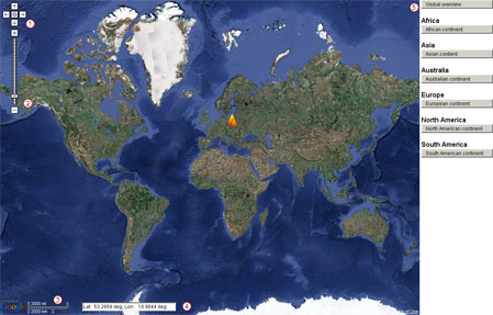
Figure 1: General overview map with coal fire region locations
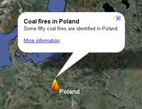 Figure 2:
 Pop up window for coal fire region The various coal-fire regions are indicated by an icon  . .
Clicking on the icon of a coal-fire region opens a pop up window
that contains a short description and a link that opens a sub page
with more information about this particular region.
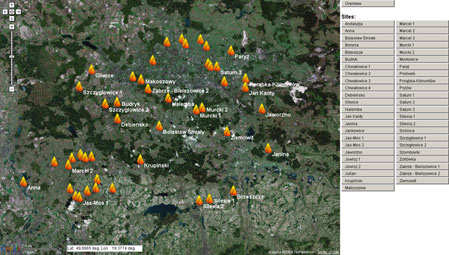
Figure 3: Overview map for a coal fire region
Each coal-fire region has a number of coal-fire locations, indicated by the navigation buttons on the right
side for all the individual fires and an "Overview" button to reset the map to its original display.
Clicking any of the site buttons will center the map on that specific coal-fire site at an appropriate zoom
level.
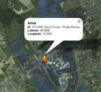 Figure 4:
 Additional information for individual coal fire
For each individual coal-fire, there is
additional information available as a pop
up window.
Click to access Online Coal and Peat Fires Map
|